 When people think of “running” and “DC,” their minds might conjure up campaign slogans and scenes from House of Cards. They might be surprised to know that there’s a lot in DC going on apart from politics — including real, feet-to-pavement running. I’ve been running here for over five years, including training for a dozen or so marathons. Here, I share some of my favorite routes to those of you who may be new to DC, visiting DC, or new to running. A lot of these routes can be linked together for as long of a run as you’d like.
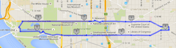
U.S. Capitol/National Mall Loop (up to 7 miles)
If you are a tourist to DC, or want to feel like one, this is the run to go on. Start anywhere on the loop, and see the U.S. Capitol, Smithsonian museums and galleries, the U.S. Botanical Garden, the Supreme Court, the Library of Congress, the National Mall, the Washington Monument, the Lincoln Memorial, Eastern Market, the World War II Memorial, and Lincoln Park. For a shorter loop (about 5 miles), cut around the back of the Capitol instead of continuing to Lincoln Park, or cut across the Mall at any point. For a longer loop, add laps around the Capitol, Lincoln Park, or the Lincoln Memorial reflecting pool, or continue past the Lincoln Memorial to Rock Creek Parkway (to continue north on Rock Creek Parkway or to meet the Capital Crescent Trail) or to the Mt. Vernon Trail. Bathrooms and water fountains are sprinkled throughout the area. Most vendors selling water and snacks on the Mall take cash only. Beware of crowds especially during protests, big national holidays (especially the Fourth of July), during the Cherry Blossom Festival, and on Saturdays in the summer. You can still run this route during those events, but you will have to dodge a lot of people. This route is mostly flat with a few small rolling hills and one significant hill at the Capitol.
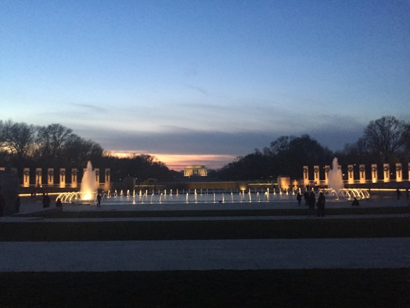
World War II and Lincoln Memorials
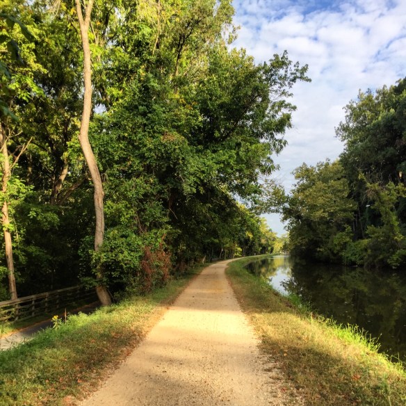
Rock Creek Parkway Connector/Out and Back (3.2 miles one way)
This is a nice little flat, paved connector path (shared with bikes) between the Mall (Lincoln Memorial) and Woodley Park/Zoo area. From the Lincoln Memorial, run on the north side over to Rock Creek and Potomac Parkway — by the giant pegasuses, not the giant horses. Once at the Parkway, you can cross this street so you are on the river side of the Parkway. This route shows off the lovely Potomac River, the Kennedy Center, and some pretty wooded areas of Rock Creek Park. The route I’ve mapped below ends at Calvert St. at the top of a steep, significant hill (a popular sledding spot), but if you turn right at the fork before this hill, the path continues northeast into the RCP/Zoo/Beach Drive area described below.


Scenic path along Rock Creek Parkway
Longer RCP/Peirce Mill/Beach Drive (5+ miles each way)
If you continue to the right on Rock Creek Parkway instead of heading up the hill to Calvert Rd., the road becomes Beach Drive. On Beach Drive, you can run along the mostly shaded, scenic, paved outer edge of Rock Creek Park and the Zoo, with access to some great unpaved trails of Rock Creek Park and many more miles of mostly shaded, paved road on Beach Drive. The map below ends at Peirce Mill, which is at the intersection of Park Road, Tilden Street, and Beach Drive. Peirce Mill has bathrooms, picnic tables, bike racks, and water fountains, and it is a starting point for several group runs and other routes you might find on the internet. (If you are coming from points east such as 14th Street or Columbia Heights, you can get directly to Pierce Mill via Park Road instead of coming up this route.) For off-road trail maps and descriptions of trails, check out Rock Creek Runner and the NPS. If you want to stay on pavement, much of Beach Drive (Broad Branch Road to Military Road and from picnic grove 10 to Wise Road and from West Beach Drive to the DC line) is closed to motorists on weekends, so it is a popular route for cyclists but there is usually plenty of room for runners. Beach Drive continues for about six miles from Peirce Mill up into Montgomery County, MD before turning into Jones Mill Road. There are bathrooms and picnic areas along Beach Drive.

From the Lincoln Memorial to Peirce Mill on RCP and Beach Drive

Peirce Mill closeup

Rock Creek
Embassy Row to National Cathedral (2 miles each way)
For a distinctly DC run without all the tourists, another option is to run along Embassy Row to the National Cathedral. Running northwest, this route is mostly uphill going past lovely embassies, the Naval Observatory, and finally the National Cathedral at the intersection of Massachusetts Avenue and Wisconsin Avenue. The route below begins at Dupont Circle but you could also start in Georgetown, run up Wisconsin Avenue, and run down Massachusetts for a nice loop.

Mount Vernon Trail/Roosevelt Island (up to 18 miles one way)
The Mount Vernon Trail is a great spot for a mindless run — no turns, no traffic, no stoplights. Oh, and it just keeps going and going. I’ve never actually run the whole thing, all the way to Mt. Vernon. But it is a great, slightly rolling pavement path, and it’s particularly convenient you are starting in Arlington, Alexandria, or the west side of DC. If coming from DC or Arlington, pick up the route in Rosslyn, on the VA side of the Key Bridge (the bridge connecting Georgetown and Arlington). At the intersection between Lynn Street and Lee Highway, there is a paved turnoff. That’s the Mt. Vernon Trail (the more rugged looking trail closer to the Key Bridge is a different route; see pictures below). Note that the Mt. Vernon Trail does get crowded on many weekends, so stay alert for bikers and keep to the right hand side. Please, please call out “on your left!” when you are going to pass someone, especially if you are on a bike.


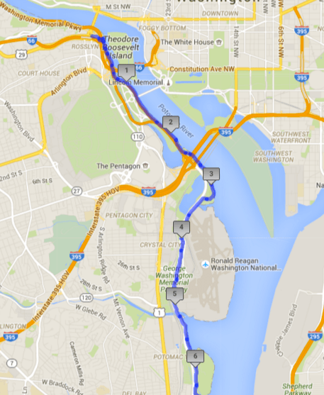
The first six miles of the Mt. Vernon Trail
A few points of interest:
(1) Roosevelt Island. Just down the ramp when you start, coming from DC, there is the Roosevelt Island parking lot. You can cross the pedestrian bridge to access the dirt path around Roosevelt Island. The island is mostly shaded and features a cool fountain/memorial area (I had run the loop countless times without seeing this!). Here is a map of the trails.
(2) Memorial Bridge crossing. If you don’t start at the Key Bridge, you can pick up the trail on the Virginia side of the Memorial Bridge, near Arlington National Cemetery. Starting on the north side of the Lincoln Memorial, run across the bridge with the giant gold horses into Virginia. Run all the way to the crosswalk in Arlington Cemetery and cross into the sidewalk on the south side (you could also add in a run down the path on the north side of Arlington Cemetery, which leads to the Netherlands Carillion). There should be a sign on your right to turn off onto the Mt. Vernon Trail. Do not try to run through traffic on Memorial Bridge, and do not try to trailblaze a more direct route to the trail; doing so is very dangerous.
(3) Gravelly Point Park. Stop for a minute before passing through the parking lot and watch the planes fly right overhead. Portapotties available here.
(4) Alexandria. I usually turn around by the time I reach Alexandria. There, I usually lose the trail (it does pick back up if you want to continue to Mt. Vernon). If you need a bathroom or refreshment, or just a walk around, Alexandria is a great spot for it.
Capital Crescent Trail (up to 11 miles one way)/C&O Canal Towpath (up to 184.5 miles one way)
Two other nice mindless, traffic-free runs. And completely flat! Wait, there’s more! You can pick between pavement (Capital Crescent Trail) and crushed gravel (C&O Canal Towpath) and in some spots, you can alternate between the two. These are popular routes for bike commuters during the week and bikers on the weekend but it usually is not as crowded as the Mt. Vernon Trail. Still, stay aware, keep to the right, and call out if you intend to pass.
Pick up the Capital Crescent Trail or C&O Towpath in Georgetown, west of K Street after it turns into Water Street. The access point is UNDER the Whitehurst Freeway, just past (to the west) of the Georgetown Waterfront/Washington Harbour, and south of the hustlebustle on M Street. Water Street dead-ends at a few boathouses under the Key Bridge and the Whitehurst; this is as far as cars can go on Water/K and is the start of the Capital Crescent Trail. The C&O Canal Towpath is the higher-up of the two paths.
If coming from Rock Creek Parkway, turn toward Georgetown at the C&O Canal sign and follow the path along the canal (there are several little bridges) to continue on to the Towpath.

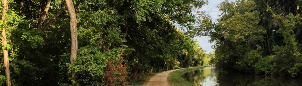
C&O Canal Towpath, with Capital Crescent Trail to the left
Note that the CCT goes from DC all the way to Bethesda and then Silver Spring. The C&O Canal ends in Cumberland, Maryland, and you can pick up the Towpath on any of several access points along the way (including Great Falls, VA and Harper’s Ferry, WVa).
For more running routes and maps, check out Washington Running Club’s site.
To find a group run in DC, check out sites for Pacers, DC Capital Striders, I Run You Run (on Meetup), or Washington Running Club. Stores such as the Georgetown Nike store, lululemon, and Maketto (a restaurant and cafe on H Street NE) also offer free group runs.
What is your favorite running route in DC? Visiting DC? I’m happy to answer any questions about DC running routes in the comments!

Hi there,I read your blog named “Best Running Routes in Washington, DC | athlettuce” on a regular basis.Your story-telling style is awesome, keep doing what you’re doing! And you can look our website about free proxy.
LikeLike
thank you for this! I am passing through on Saturday and need a 5mile run so I think you’ve mapped one out perfectly for me as a total tourist. hoping I can find a close up of the map to make sure I dont go wrong…
LikeLike